Cape Verde on the World Map: Where the Island Nation Is Located
Cape Verde (Cape Verde Islands) on the world map: where the archipelago in the Atlantic is located, its history and what makes it interesting.

The Republic of Cape Verde, also known as the Cape Verde Islands, is a unique island nation located in the Atlantic Ocean. This former Portuguese colony gained independence in 1975 and is today one of the most stable and developed nations on the African continent.
On modern maps, the country is designated by two equivalent names: Cape Verde (Portuguese name Cabo Verde) and Cape Verde Islands (the English version). This African nation is part of Macaronesia — a group of archipelagos in the northern part of the Atlantic Ocean, also including the Azores, the Canary Islands, and Madeira.
The name "Cape Verde" comes from the country's location opposite the eponymous cape in Senegal, the westernmost point of continental Africa. Although the territory itself is predominantly arid, the historical name has stuck and is used to this day.
When searching for Cape Verde on a map, it is important to note that it is not a landmass on the continent but an island group consisting of 10 major and 8 minor islands in the central part of the Atlantic Ocean, spread over a considerable distance from the African coast.
Geographic Location of Cape Verde
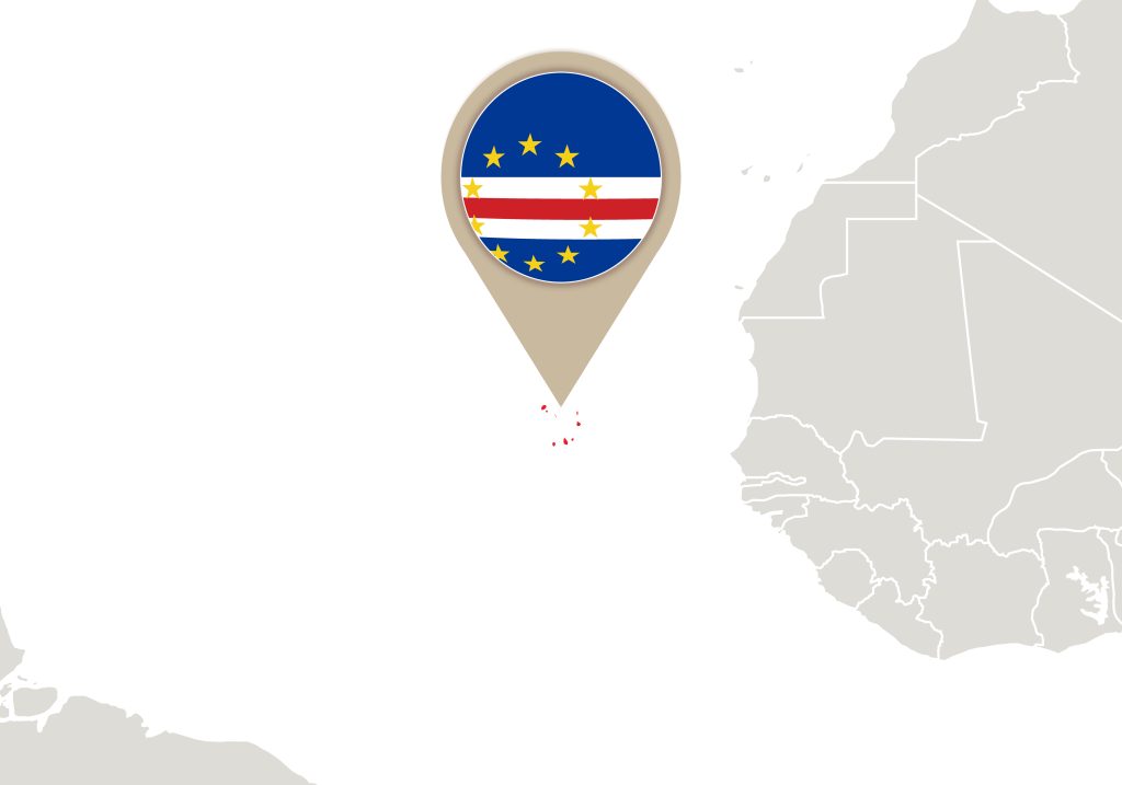
The Republic of Cape Verde is located in the central part of the Atlantic Ocean, 570 km from the western coast of Africa. The geographic coordinates of the island nation are 16° north latitude and 24° west longitude. The territory is situated at a distance of approximately 450 km from Senegal, opposite Cape Verde, which gave the nation its name.
The island nation of Cape Verde consists of an archipelago of 10 major islands, conditionally divided into windward and leeward groups:
- Windward (Barlavento): located in the north and include Santo Antão, São Vicente, Santa Lucia, São Nicolau, Sal, and Boa Vista
- Leeward (Sotavento): located in the south and include Maio, Santiago (the largest in the archipelago), Fogo, and Brava
In the context of world geography, Cape Verde is part of Macaronesia — a group of island territories in the northern part of the Atlantic Ocean. This location determines strategic importance, as the territory historically served as an important point on maritime trade routes between Europe, Africa, and America.
The nation has no land borders with other countries. The nearest neighbors by sea are:
- Senegal (570 km to the mainland)
- The Gambia (640 km)
- Mauritania (850 km)
- Canary Islands (1,350 km to the north)
When searching for Cape Verde on a world map, you should look for the intersection of the 16th parallel north and the 24th meridian west in the Atlantic Ocean. The territory covers a maritime area of approximately 4,033 km².
Territorial Characteristics of Cape Verde
Cape Verde is a compact island nation with a total area of 4,033 km². This makes it one of the smallest nations in Africa, comparable in size to Rhode Island (USA) or French Polynesia.
The area of the main territories is distributed as follows:
- Santiago: 991 km² (largest in the archipelago)
- Santo Antão: 779 km²
- Boa Vista: 620 km²
- Fogo: 476 km²
- São Nicolau: 388 km²
- Maio: 269 km²
- São Vicente: 227 km²
- Sal: 216 km²
- Brava: 64 km²
- Santa Lucia: 35 km² (uninhabited)
The coastline of the entire territory is 965 km long. Due to its volcanic origin, the territory has a complex topography with numerous bays and natural harbors, which historically facilitated the development of seafaring and maritime trade.
The territorial waters of Cape Verde extend 12 nautical miles (22.2 km) from the coastline. The country's exclusive economic zone covers an area of 734,265 km², which significantly exceeds the size of the terrestrial territory.
Special Characteristics of Cape Verde's Territory
- Volcanic origin of all territory
- Predominantly mountainous terrain with scenic valleys
- Presence of an active volcano, Pico do Fogo (2,829 m)
- A combination of rocky coasts and sandy beaches
- Significant distance between territories
- Freshwater scarcity and dependence on desalination
Administrative Division of Cape Verde
The capital of the Republic of Cape Verde is the city of Praia, located on Santiago. It is the largest city in the country with a population of about 160,000 people, which represents approximately one-third of the nation's total population. The capital Praia is the main administrative, economic, and cultural center.
Administratively, Cape Verde is divided into 22 municipalities (concelhos), distributed across the 10 main land areas of the Cape Verde Islands:
Windward (Barlavento)
- Santo Antão: Ribeira Grande, Paul, Porto Novo
- São Vicente: Mindelo (the country's second-largest city and an important cultural center)
- Northern territory: Ribeira Brava, Tarrafal
- Sal: Espargos (an important tourist center with an international airport)
- Boa Vista: Sal-Rei
Leeward (Sotavento)
- Santiago: capital Praia, São Domingos, Santa Catarina, Tarrafal
- Maio: Porto Inglês
- Fogo: São Filipe
- Brava: Nova Sintra
Main Urban Centers
- Praia — capital, administrative center, and largest seaport
- Mindelo — important cultural and educational center on São Vicente
- Espargos — center of international tourism on Sal
- São Filipe — historic center and agricultural hub
- Santa Maria — popular resort town on Sal
Each municipality has its own local government bodies, which ensures effective management of territories despite their geographic separation. The system of administrative division takes into account the historical, economic, and demographic characteristics of each territory.
Basic Information About Cape Verde
Form of Government
Cape Verde is a parliamentary republic with a democratic system of governance. The country's state structure is based on the principles of separation of powers:
- Head of state — president, elected for 5 years
- Executive power is exercised by the government headed by the prime minister
- Legislative body — the National Assembly, a unicameral parliament
- Independent judicial system with the Supreme Court at its head
Population
Demographic characteristics of Cape Verde:
- Total population: approximately 560,000 people
- Ethnic composition: predominantly Creole (mixed African-European descent with Portuguese roots)
- Official language: Portuguese
- Creole language (Kriolu) is widespread — a mixture of Portuguese with African dialects
- Literacy rate: over 85%
- Average life expectancy: 72 years
Economy
Main economic indicators and characteristics:
- GDP per capita: approximately $3,600
- Main economic sectors:
- Tourism (over 25% of GDP), especially on Sal and Boa Vista
- Services sector
- Fishing (tuna, mullet, and other species)
- Agriculture
- Currency: Cape Verdean escudo (CVE)
- Main trading partners: EU countries, USA, China
Development Indicators
Cape Verde is among the most developed nations in Africa by several indicators:
- High human development index in the region
- Political stability
- Developing market economy
- Sustainable economic growth
- Active international cooperation
Natural Features of Cape Verde
Climate
Cape Verde is characterized by a tropical trade-wind climate with special characteristics:
- Average temperature: 20–25°C year-round
- Two seasons:
- Dry (December–June)
- Wet (August–October) with rare rainfall
- Annual precipitation: 100–300 mm
- Influence of trade winds
- Possibility of dust haze (harmattan) from the Sahara Desert
Topography
Topographic features are due to the volcanic origin of the territory:
- Mountainous terrain on most territories
- Highest point of the archipelago: active volcano Pico do Fogo (2,829 m)
- Last eruption: 2014–2015
- Types of landscape:
- Mountainous territories (Santo Antão, territory with the capital city, volcanic zone)
- Flat territories (Sal, Boa Vista, Maio)
- Rocky coasts
- Sandy beaches
Natural Resources
Main natural resources and minerals of the island nation:
Marine resources:
- Rich fish stocks (tuna, mullet)
- Sea salt
- Potential for aquaculture development
- Sea turtles (protected species)
Mineral resources:
- Pozzolan (volcanic material)
- Volcanic tuff
- Basalt
- Limestone
- Pozzolan and salt (main mineral resources)
Renewable energy sources:
- Solar energy
- Wind energy
- Geothermal potential
Fauna of the Cape Verde Islands
In the territories of Brava and Santo Antão, as on other parts of the archipelago, introduced animal species are found, including monkeys and dogs. Marine fauna is represented by diverse fish species and sea turtles, which lay eggs on the beaches of Sal and Boa Vista.
Flora
The territory is home to pines and eucalyptus, introduced during the colonial period to combat soil erosion. Deforestation in the past has led to the near-disappearance of rivers — today their beds fill with water only during the rainy season.
Ecological Characteristics
Main environmental challenges and characteristics:
- Limited freshwater supplies — the territory depends on seawater desalination
- Fresh water sources are rare
- Risk of desertification
- Soil erosion
- Need to protect the marine ecosystem
- Programs for biodiversity conservation
The Importance of Geographic Location for Cape Verde's Development
The geographic location of Cape Verde plays a key role in the nation's development, determining its unique advantages and challenges:
Strategic Advantages of Location
- Position at the intersection of maritime routes between Europe, the African continent, and America
- Potential for international tourism development due to climate and natural conditions
- Opportunities for maritime and air transport development
- Extensive economic zone for fishing development
- Favorable conditions for renewable energy use
Geographic Challenges
- Isolation from the continent, affecting logistics
- Limited natural resources
- Dependence on maritime transport
- Vulnerability to climate change
- Need to develop inter-island communication
Interesting Facts About Cape Verde
The territory represents a unique combination of African and Portuguese cultures. The nation is actively developing as a tourist destination, particularly Sal and Boa Vista, attracting beach holiday and water sports enthusiasts. Mindelo on São Vicente is famous as the cultural capital of Cape Verde with rich musical traditions and Portuguese colonial heritage.
Development Prospects
Despite geographic challenges, Cape Verde is successfully using its location for development:
- Becoming an international tourist destination
- Development as a transport hub between continents
- Strengthening positions in regional trade
- Implementation of innovative energy solutions
- Development of sustainable fishing
The location of Cape Verde on the world map has largely determined the path of development of this island nation. Skillful use of geographic advantages and consistent overcoming of challenges related to its position allow the country to develop successfully and strengthen its role in the world community. The unique combination of African roots and Atlantic location makes Cape Verde a special place where geography plays a key role in shaping the nation's present and future.